Atlas-T
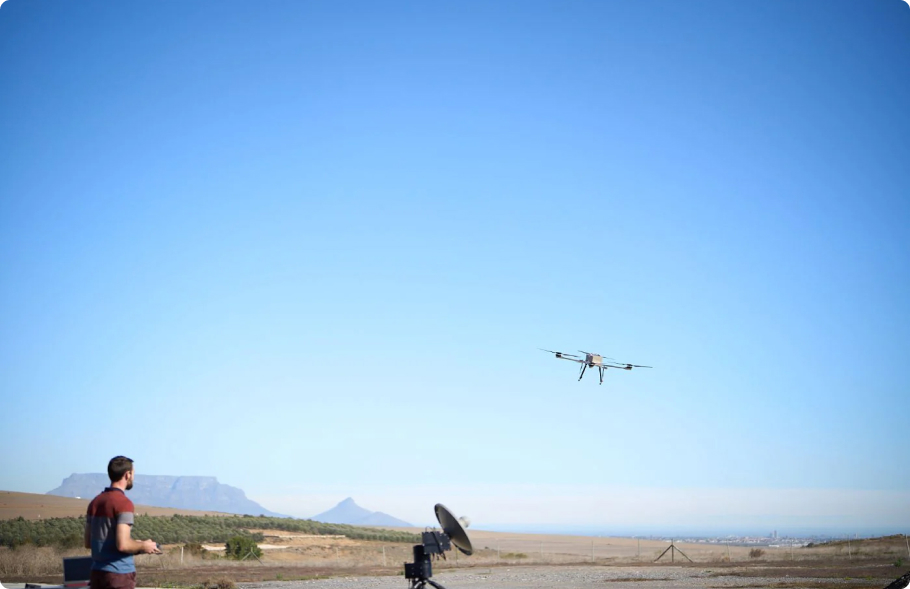
YOUR TACTICAL LONG RANGE PARTNER
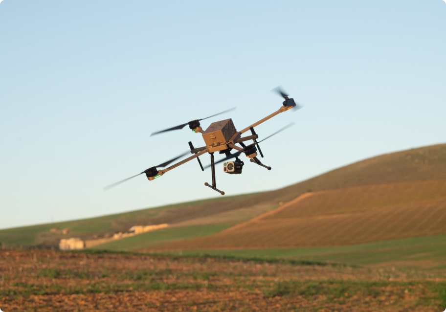
A rugged, lightweight solution, designed for rapid deployment and mobility. Ground-breaking flight times of up to 80 min with quick swap batteries, for more time in the air than any other battery operated platform.
Engineered with highly efficient motors and props, providing a low noise footprint for discretion and stealth.
Built-in safety features as well as redundant systems ensure convenient and safe operation in varied environments. Multi-payload support, robust technology, and strenuous field testing enables the system to meet your demands.
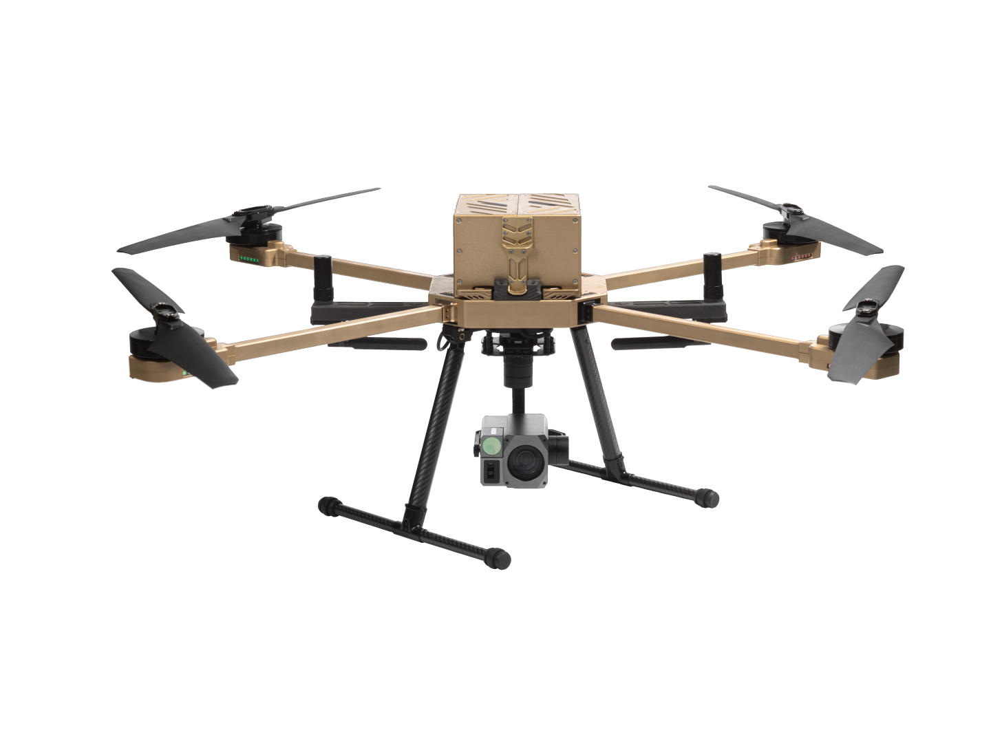
Atlas-T Design
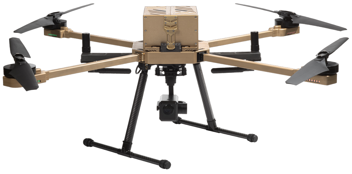
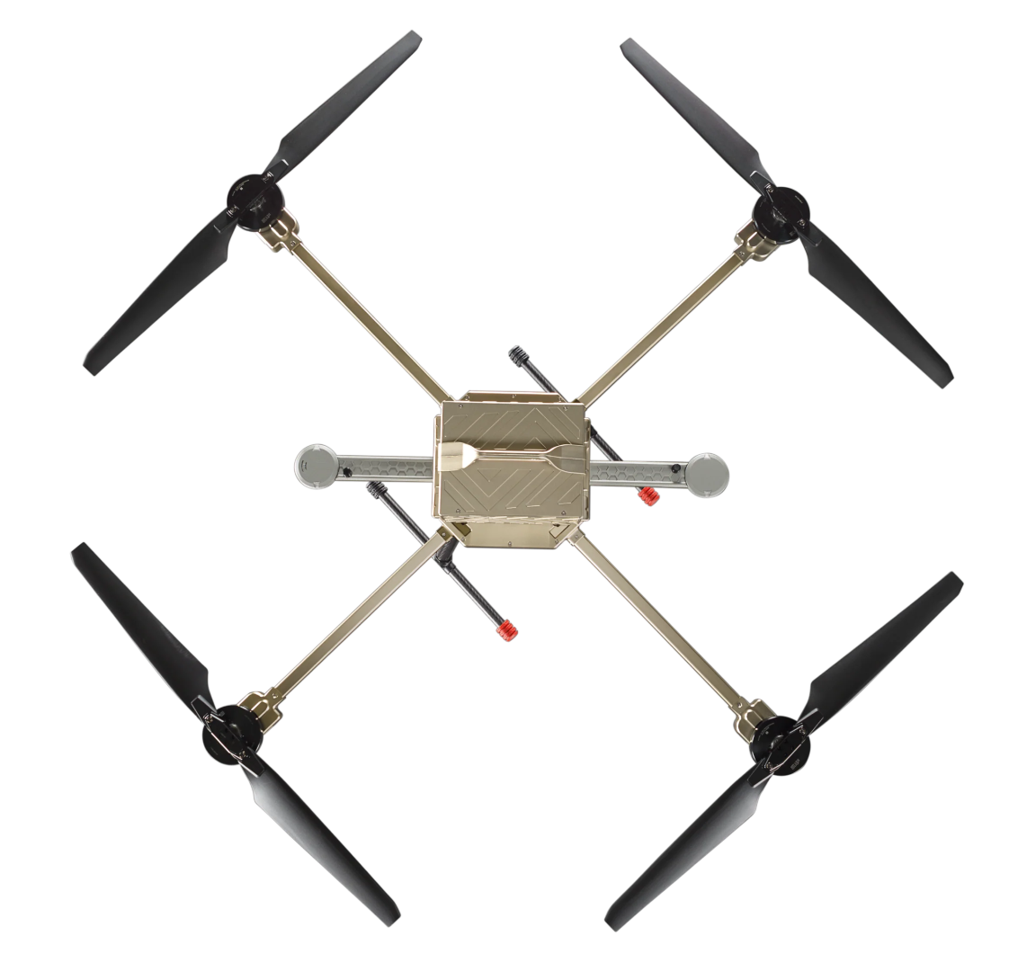
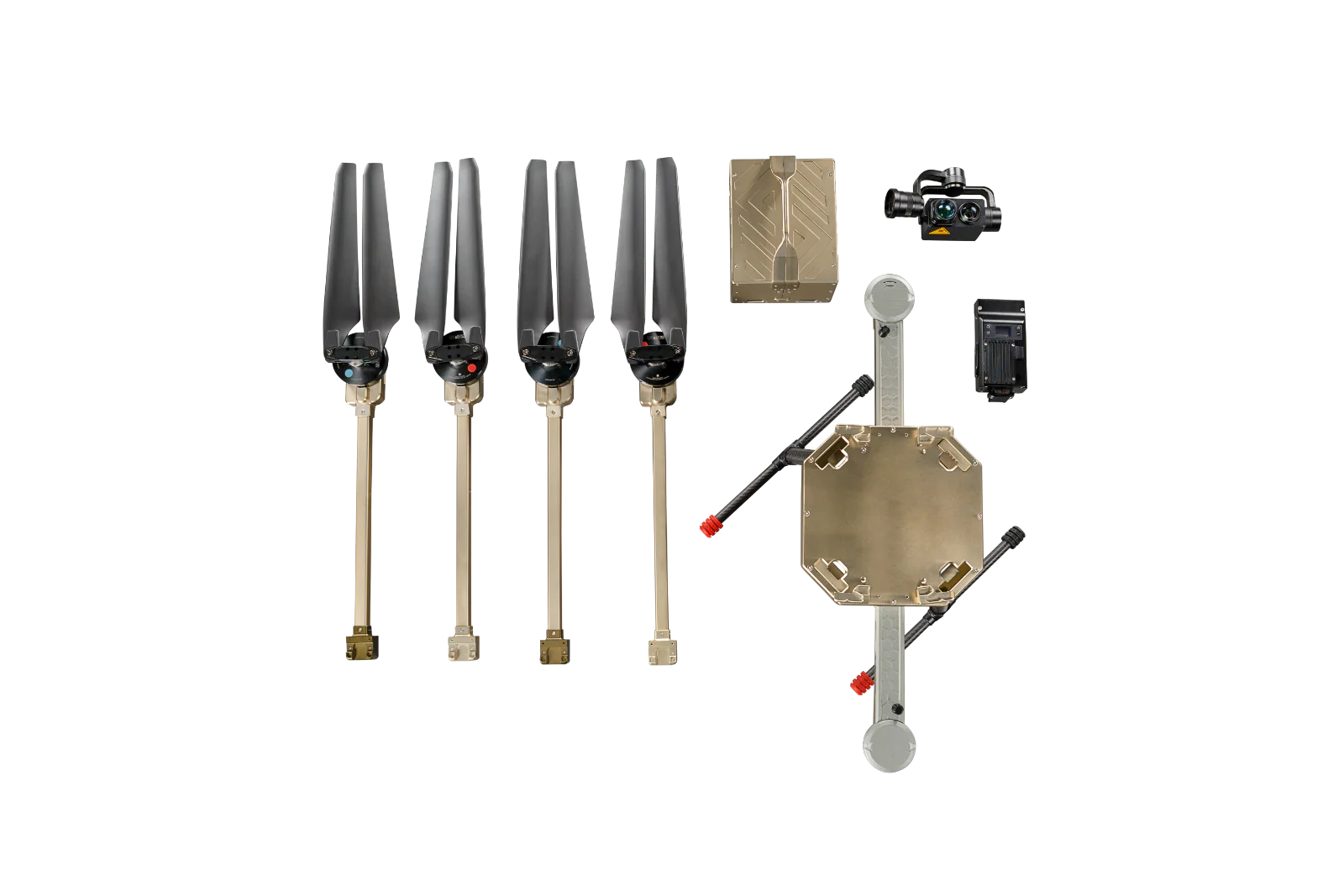
The innovative design in the new ATLAS-T airframe breaks the mould for high endurance UAV aircraft. Using the strongest materials possible, precision engineered and meticulously finished, the new ATLAS-T is a premium product both in aesthetic and performance.
Flight Time of 60min+ with Heavier Payloads
Low noise footprint for stealth and discretion
Lightweight & rugged airframe
Multiple built-in safety features
RTL – Return to Launch (aka home)
Dual GPS for accuracy of up to 1 cm and navigation redundancy
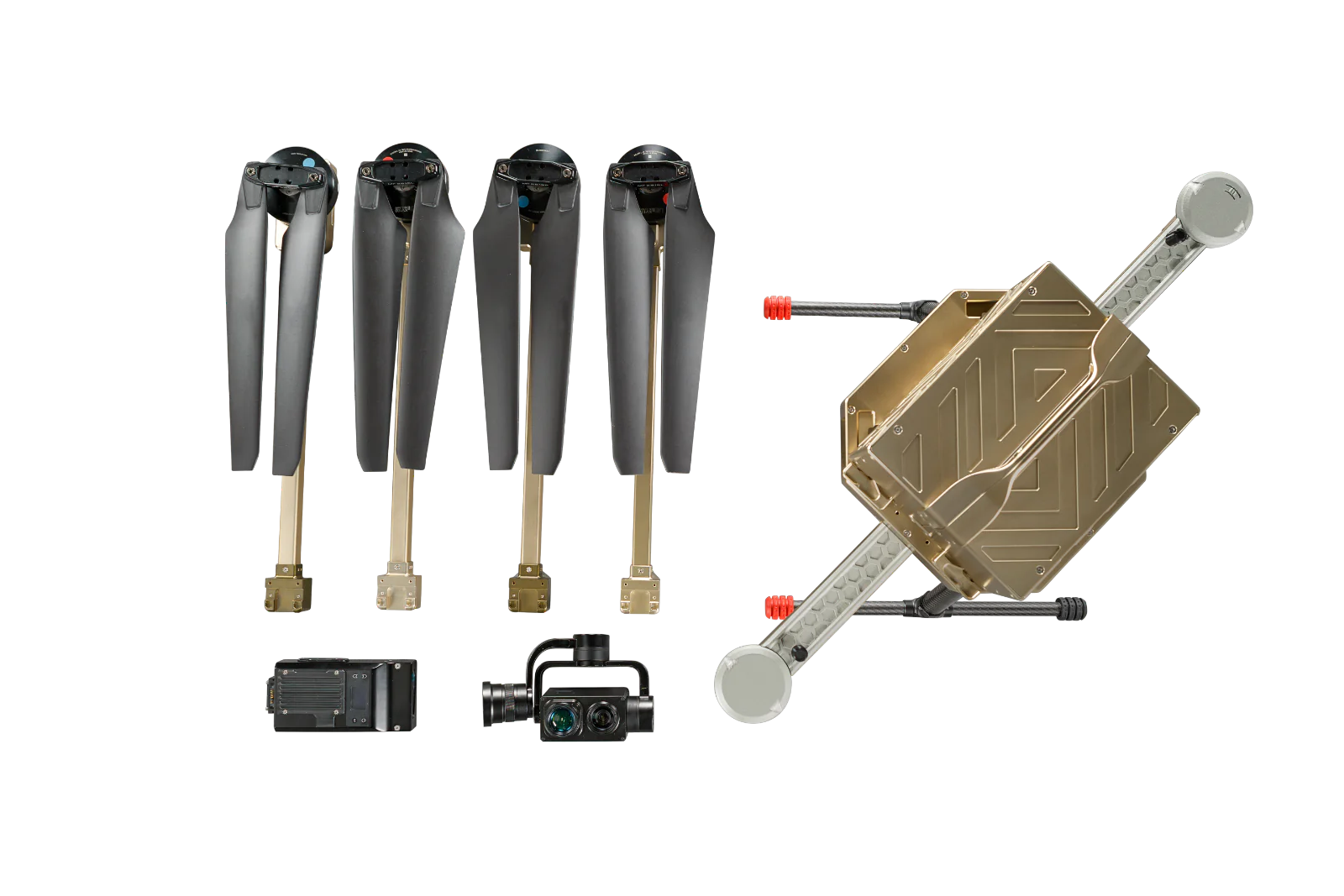
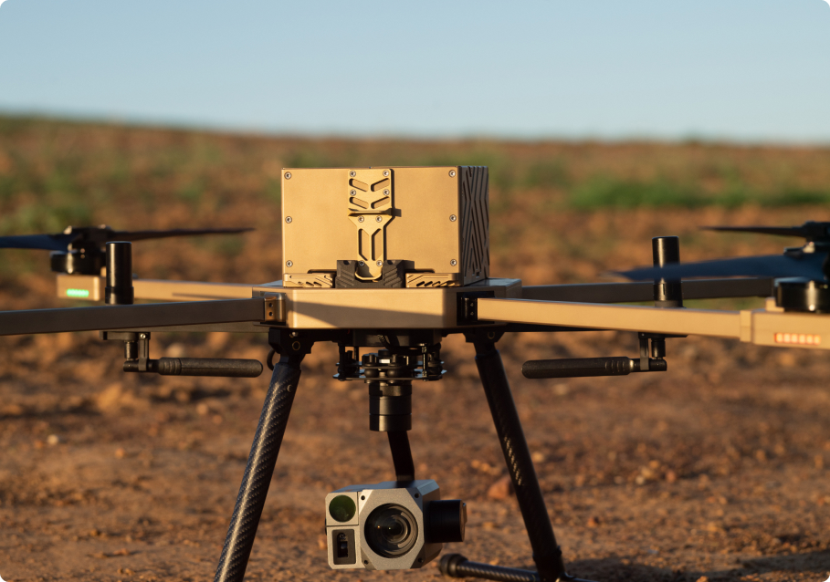
Long, lightweight carbon fibre landing gear for harsh environments
Hot shoe for gimbal, open LAN port for custom integration
28” light carbon propellers for increased stability and response control
Custom motor KV for performance at your take-off altitude
endurance

The ATLAS-T has been carefully designed to provide the ideal balance between Endurance and Range, 80 min with no payload, 60 min with payload.
Accuracy

ATLAS-T boasts an impressive accuracy level, achieving pinpoint precision with less than 1 cm pointing accuracy thanks to its dual GPS system.
CruiseSpeed

With a max cruise speed of 50 km/hour, ATLAS-T is designed for swift deployment, allowing you to respond to critical situations promptly. Its quick launch capabilities ensure you are up and running within minutes
payload

The ALTLAS-T accommodates various multiple/various payloads including high-resolution mapping systems to advanced surveillance EO/IR cameras with object tracking and more.
Power Source

Electric
Lithium-ion Polymer battery (12S2P)
network

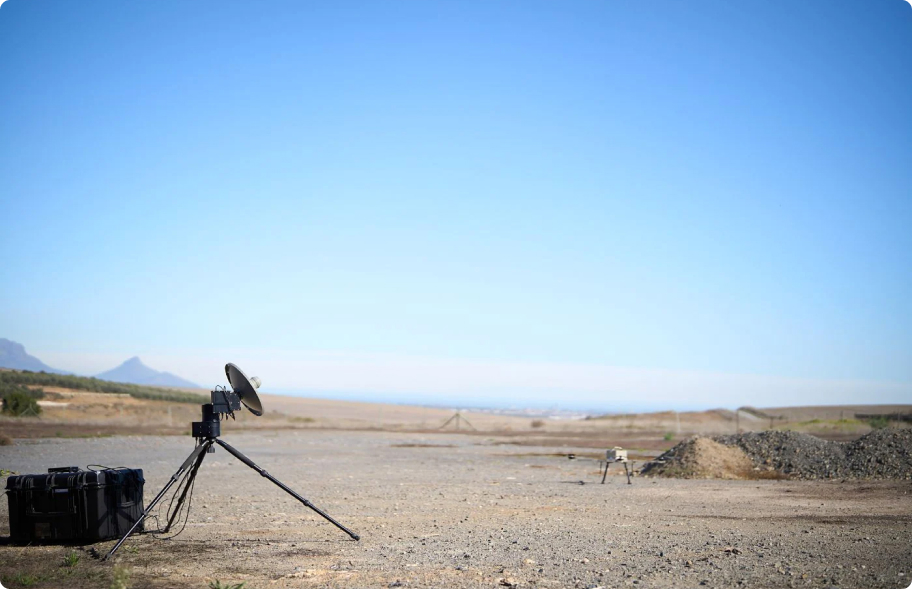
Security is at the core of the ATLAS-T’s design. Utilizing advanced encryption protocols and secure communication channels, the UAV ensures that mission-critical data remains protected from unauthorized access.
vtol

The Vertical Take-Off and Landing (VTOL) capability allows the ATLAS-T to operate without the need for extensive runways or launch infrastructure. This agility is vital for conducting surveillance in challenging terrains and remote locations, making it the ideal choice for diverse border landscapes.
Autonomous

The ATLAS-T is designed with the user in mind. Its intuitive interface and autonomous flight modes, including waypoint navigation and follow-me, make piloting effortless, allowing you to focus on mission objectives. Atlas-T puts safety first with obstacle detection and avoidance systems, geo-fencing, and return-to-home features.
data & Intelligence

In the heat of action, real-time data and intelligence are paramount. The ATLAS-T excels in relaying live feeds and critical information to command centers, providing decision-makers with the insights they need for swift and informed actions.
Isolated flight controller board improving stability in flight.
Miniaturized IC board design fits perfectly in the compact form factor.
Direct interfaces for connecting external modules.
Onboard subsystems (Networks, RC, Flight Control and Power) pre-integrated and calibrated, providing a ‘plug-and-play’ like experience.
Robustness of the ATLAS-T is further enhanced with fatigue eliminating motor to ESC interfaces and redundant subsystems.
Improved rigidity of the airframe
- greatly reduces vibration and
- enhances durability along with the compact and rigid design
- subsystems are subjected to much less wear and tear
Reduced vibration enable
- more efficient operation of motors
- extending flight time
- better control of the UAV during manual flights
Atlas-T Applications

Safeguard critical infrastructure and monitor sensitive locations with unparalleled precision.
Surveillance is the close observation of a person, group of people, behaviors, activities, infrastructure, building, etc for the purpose of managing, influencing, directing or protecting. There are several different methods of surveillance namely GPS tracking, camera observation, and stake-outs. Additionally, you can use data mining, profiling, and biometric surveillance.
Nextech’s UAVs and sub-systems solve for the constraints with traditional surveillance methods which are typically limited by the stationary nature of handheld or fixed cameras and high costs involved, for example with Helicopter surveillance.
Atlas-T provides the ideal solution to these constraints and limitations faced by other surveillance methods with easier, faster, and cost-effective methods of high-precision data collection and advanced surveillance and security missions.
Key advantages of Nextech’s UAV surveillance are the Drones’ ability to enter narrow and confined spaces, produce minimal noise, speed and endurance, long-range coverage, and are equipped with night-vision cameras and thermal sensors. For this reason, they provide imagery that the human eye is unable to detect, day and night, by rapidly covering large and difficult-to-reach areas, and ultimately reducing security staff headcount and costs.
Industries such as petrochemical, oil and gas, construction, communications, and utilities carry out regular inspections of their equipment to ensure it is in safe working order. Human inspections additionally can only go so far as people are often limited when it comes to heights or confined spaces. An increasing number of companies are beginning to use drones for inspection as they address the operational challenges faced by human inspections.
Things such as corrosion identification, detection and analysis of hairline cracks, spillage and leak detection, dilapidation assessments, and land surveys are much more easily carried out by drones than by hand. Data is collected and sent back to a computer in real-time for assessment. Any problems are dealt with quickly and efficiently, causing minimal disruption to operations.
Using an inspection drone in place of, or in addition to, conventional methods of facility management provides an untapped potential for saving costs via activities such as automated maintenance, integrity, and surveillance workflow, and automated data gathering and analysis.Drone technology also provides predictive insights on facilities, which drives operational decisions, and leads to the improvement of business processes.
Nextech’s methane sensor detects gas of up to 100m distance and methane 100,000 in part per million meter. The sensor interfaces with UAVs GPS data and provides accurate LAT and LONG readings which can be mapped with the Google Earth app.
While drones are rapidly demonstrating its value across many industries, its application is particularly dramatic with drones in Emergency Response operations where the extra range and reach of drones make its presence felt like nowhere else. Unlike most other applications which are fairly routine and predictable, SAR operations are very unpredictable and each operation unique in its execution. There are 3 key factors that are critical in the success of an Emergency Response mission:
- Time criticality:
A life threatening event has happened to someone out of the blue, And speed of response is of the essence to rescue this victim - Commuting congestion:
The target location where emergency relief is needed might require traversing unhelpful & congested traffic conditions - Terrain:
Rescue operations are generally by definition needed in inaccessible terrains which might have caused the emergency in the first instance. Because it is difficult to navigate, ‘Eye-In-The-Sky’ Situational Awareness is essential. Search times can be significantly reduced while limiting potential risk to the party being rescued as well as rescuers.
Speed of response through rapid deployment & overcoming congested urban areas, extreme maneuverability & high endurance capability, thermal camera gimbals to detect human activity, zoom cameras with highest spec optical zoom capabilities and drop-systems that support delivery of emergency supplies in critical situations make the Atlas-T your ideal UAV for any emergency response operation.
Optimize your crop management with multispectral imaging, NDVI analysis, and precision agriculture techniques.
Managing huge farms with limited manpower requires more advanced use of technologies, including drones. One notable growing industry within the agricultural industry is the rise of cannabis farmers, globally. Many of these farmers use drone technology to bring precision agriculture to their cannabis fields for plant counting and canopy sizing. Therefore, instead of “walking the field” to estimate size, farmers are using drones (and AI) to count and size plants.
Nextech’s intelligent UAV technology generates quantitative analytics to evaluate the varieties, opportunities for surface replanting and monitors sexual maturity and harvest opportunities to prevent the loss of CBD concentration. Another major benefit of using drones in hemp and CBD farming is the ability to monitor plant health. This imagery is also ideal for capturing crops and processing vegetative indices (such as NDVI or VARI). It also allows for counting of crops and identifying water pooling.
Performing aerial photography with helicopters and planes is expensive, requires trained personnel, and cannot be undertaken at certain times due to safety regulations. A mapping UAV provides the ideal alternative; they are cheaper to operate, can be instantly deployed, and can be programmed pre-flight to follow a route via waypoint grids. In addition to this, the data is stored as a hard copy which can be easily inputted in geo-mapping software, allowing the swift implementation of the data.
Monitor wildlife, track changes in vegetation, and assess environmental conditions with ease.
Nextech’s Atlas-T drone enables all wildlife control methods by obtaining information regarding the position and condition of the game and land with high-precision data for topographical surveys, multispectral imaging, object tracking using LiDAR sensors and thermal imagers, and advanced security and surveillance of game.
Additionally, the Atlas-T is engineered for covert operations and subtle reconnaissance. Its signature feature emphasizes low visibility and a discreet acoustic signature, making this drone perfect for anti-poaching missions, as well as animal monitoring without disrupting and alarming the animal.
Powered by real-time data and intelligence providing live feeds and data transmission to central command centers, empowering wildlife and game reserves to make informed decisions and respond swiftly to any threatening situations.
Nextech’s UAVs provide long-range and high endurance flight missions that solve for missions in the wildlife and game industries, namely anti-poaching operations, species identification, migration tracking, topographical mapping and surveys and habitat management. However with Nextech’s cutting edge technology enabling multiple payload integrations our UAV and UAs solutions can be tailored to your specific operation.
Flight Time
80 min (without payload) / 60 min (with payload)
Maximum Forward speed
18 m/s
Maximum altitude
4000 m (KV specific)
Maximum take-off Weight
15 kg
Maximum Wind Speeds
45 km/h
Gusts op to
55 km/h
Operating Temperatures
min: -5°C RTF | max: 50°C RTF
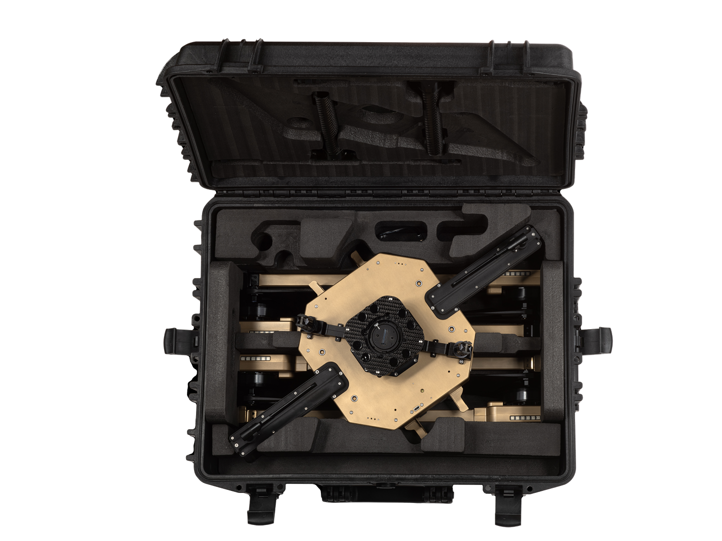
Dimensions (Folded/packaging)
176H x 726H x 533W
Dimensions (Flying)
176H x 1106WB
Dimensions open (mm) / diagonal length
835L x 835W x 350H /1180mm
Handling
Highly compact design, lightweight and foldable frame – makes handling and transporting the ATLAS-T airframe a breeze.
CONFIGURE & ORDER YOUR AIRCRAFT
Long Endurance Drone