Surveillance & Security
How our drones help
Surveillance is the close observation of a person, group of people, behaviors, activities, infrastructure, building, etc for the purpose of managing, influencing, directing, or protecting. There are also several different methods of surveillance. Methods include GPS tracking, camera observation, and stake-outs, Additionally, you can use data mining, profiling, and biometric surveillance.
Traditional observational surveillance methods are typically limited by the stationary nature of the camera. The camera is therefore usually handled manually or fixed upon a tripod or other structure. Aerial surveillance with a helicopter achieves the desired result but is also very costly.
Unmanned aircraft systems provide the ideal solution to the problems and limitations faced by other surveillance methods. Drone surveillance presents an easier, faster, and cheaper method of data collection. Consequently, there are also a number of other key advantages. Drone planes can enter narrow and confined spaces, produce minimal noise, and are equipped with night-vision cameras and thermal sensors. For this reason, they provide imagery that the human eye is unable to detect.
UAVs can quickly cover large and difficult-to-reach areas, reducing staff numbers and costs. They additionally do not require much space for their operators.

Different parts of the security industry have differing requirements. For example, one can distinguish between two types of approach: monitoring Lines and monitoring Sites.
In-Line monitoring, fixed-wing UAVs perform high-level highway, coastal, and border surveillance. They can also provide high-level feedback on illegal border crossing, smuggling, or wild animal traffic.
In terms of monitoring Sites, multi-rotors are more common. They allow for higher maneuverability and can hover more easily. In addition, UAVs can provide live streaming of detailed data. They can follow objects or intruders from a safe distance and quickly cover a large area. They also record images that can identify whether part of a forest or a slag heap is missing. UAVs have additionally found other applications in industrial plants. They reduce the costs of asset theft, as well as monitoring and verifying the quality of employee work.
Because of current global financial conditions, oil are focusing their attention on less developed areas the Middle East and Africa. This brings a different series of security challenges such as:
- Prevention of pipeline sabotage and oil theft and illegal oil trafficking
- Installation of a high performance security fencing UAV / Drone perimeter detection and response systems
- Re-positioning of assets and slow moving heavy lift vessels in offshore Oil & Gas
UAVs provide a rapid response and fast “eyes on” to the target area. They also provide live updates control stations while active waypoint tracking can be maintained based on the target parameters, like thermal signatures.
A key advantage of a UAV is its ability to collect imagery. The imagery is ideally suited for reconnaissance or rapid situation awareness. It has an application for ground force units to detect and monitor potential threats from a safe distance. UAVs in perimeter security reduce the requirement for foot patrols by security guards. They also provide an additional oversight in instances where deployed security guards are to ensure their adherence to patrolling routines.
The speed, size, maneuverability, and additional technologies make UAVs the perfect supplement to ground security. They allow security teams to perform monitoring tasks more quickly and efficiently. For this reason, drones have a competitive edge over stationary cameras, as intruders can’t easily step out of sight. They can easily cover areas that are normally out of reach.
Counter Piracy Operations: UAVs are useful to monitor, analyze and anticipate pirate vessel movements. This allows security forces to identify hazardous areas, potential assault locations and timings and evaluate piracy trends around the world.
Super Yacht Security: UAVs are involved in protection services for superyachts. They help crews to stay safe, reduce delays and minimize cost overruns. Such services also add value by reducing insurance premiums while assuring stakeholders that company assets are secure.
UAVs are instrumental in managing the critical facets of security & safety at major events. For example, event security infrastructure, spectator and crowd control, and safety to overall health and safety planning.
This includes the completion of initial security risk assessments to developing bespoke security infrastructure solutions. Areas covered include general security, such as vehicular access. Landscapes, fire evacuation procedure and adaptation of the original building design are also covered.
In addition to monitoring and rapid reaction, UAVs can provide detailed visual documentation of sites. This enables effective analysis, risk management, and security planning. Abu Dhabi’s security company, uses UAVs to supplement its security system, especially around ports. UAVs also monitor and assess the scale of accidents. This information enables authorities to delegate personnel more efficiently.
Traffic monitoring is necessary for collecting data that provides a detailed description of the use and performance of road networks. There are two main ways to collect traffic data: by manually observing the roads, or by using electronic equipment to monitor roads at specific times.
The data collected in traffic monitoring supports the safety, performance, and maintenance of the roads. Many traffic monitoring organizations use helicopters to achieve aerial views, or use cameras fixed above the roads. Both of these methods only serve one particular purpose, therefore cameras are difficult to move around efficiently, and using helicopters is too costly to use for repetitive road monitoring.
Aerial surveillance drones offer a much more efficient and cost-effective alternative to helicopters and static cameras. Drones also offer several advantages over traditional methods of traffic monitoring. They use waypoint navigation, which allows them to fly along specific routes repetitively; they can also fly over specific roads and in specific situations.
Unmanned aircraft are also significantly cheaper than helicopters, meaning you can deploy them more often, thus increasing the overall performance of the traffic monitoring operations.
Special Weapons and Tactics teams, also known as SWAT teams, are elite tactical units trained to perform high-risk operations like hostage rescues.
Members of a SWAT team are equipped with heavy-duty body armour, and often carry specialized firearms; they are also aided whenever possible by aerial assistance. Aerial assistance is essential in SWAT operations as it facilitates the tactical implementation of multi-angle information. This type of aerial assistance has traditionally been via helicopter.
However, one of the main problems with helicopters location. Since they are not typically deployed from rural locations, response time is slower and units have to wait. Helicopters are also very noisy, and costly to run because they require professional personnel to operate them. Drone planes provide a safe and cost-effective alternative to helicopters.
These unmanned aircraft systems can deploy instantly when needed, cost a lot less than a helicopter, and also have a very low noise footprint so they’re suitable for use in sensitive missions. All of this means that drones can be deployed more frequently to SWAT teams, leading to safer conditions for both team members and civilians alike.
Poaching is the illegal hunting, capturing, or killing of non-domestic animals. The practice is therefore in direct contradiction to the Endangered Species Act. Acts of poaching also encompass a failure to comply with the regulations surrounding hunting. Regulations include hunting without a license, hunting at illegal locations, and hunting with illegal methods.
There are a number of anti-poaching measures in place in National Parks and the habitats of game and wildlife. They include the pre-emptive removal of horns to discourage poachers, as well as dying the horns a bright color to make them undesirable to poachers. Poaching is typically related to large parks and habitats, and close surveillance of these areas is difficult.
Aerial surveillance using helicopters can help to improve measures somewhat; however, helicopters are costly and noisy to they are not always a viable option. A surveillance drone is the ideal solution to the problems faced by other anti-poaching methods. Drones are equipped with not only cameras but also thermal sensors and sniffers that enable them to detect poachers and hazardous gases.
Unmanned aircraft can cover large areas at a fraction of the cost of a helicopter; they can also deploy rapidly from an onsite location, and they have a very low noise footprint which doesn’t disturb the animals or alert the poachers to the presence of the drone.
Tactical Drone
Object tracking is key to security and surveillance operations. With the advances in low altitude fixed-wing VTOL and Multirotor drone technologies with their ability to hover in the vicinity of a ROI or POI, mobile airborne object identification and tracking has become a reality.
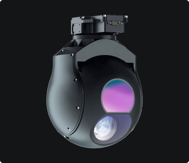
Tactical Drone Gimbal
A major development for security and surveillance industries is the recent design of a tactical gimbal for a tactical drone. The gimble is specifically capable of keeping a moving target of interest at the center of the image plane. Additionally, there is a Region-of-Interest (ROI) that encloses the target’s image generated through the combination of a visual object detector and a visual object tracker.
The proposed solution combines a fast and reliable deep learning visual object detector and tracker. Specially suited for low computational power implementation with built-in capabilities to guarantee convergence of the target image to the origin of the image plane. It also reaches the extent of human face detection and tracking.
Features
Direct drive torque motor stabilization produces stable video even at 30x optical zoom or up to 1.3° vertical field of view. The Tactical Gimbal is also available with multiple sensors, including a high-sensitivity 640×480 IR night sensor with a unique 60 mm IR lens.
Electronic Video Stabilization with roll correction, removes the high-frequency jitter often found on small unmanned aircraft platforms. This significantly reduces the operator workload and allows it to concentrate on the mission objective.
The Tactical Gimbal will automatically hold the video centred on the scene, independent of the aircraft movement. Encoder The video is encoded with H.264 compression format to support IP datalink options and to explicitly reduces datalink system bandwidth requirement.
Onboard Video Processor
All high-performance long-range gimbals today have an onboard video processor which is a dedicated hardware processor that receives the video stream from the sensors inside the gimbal, processes the video and sends it to the datalinks. This processor performs:
- Software stabilization of the video stream.
- Encoding of the video stream ( H.264 format) prior to sending the video can be sent through an IP datalink
- Object tracking. Video processor steers the gimbal to maintain the object of interest inside the video frame, even if the object is moving and the aircraft platform is moving.
- The operator can also designate a moving or static target and the gimbal will lock into this target for hands-free tracking of moving objects.
- The target will additionally remain locked even if the aircraft platform is moving or loitering.
- The target will also remain locked if the object is moving relative to the platform, for example if the moving vehicle is tracked on a highway.
- Operator can zoom in to the narrowest FoV, while the gimbal will remain locked on the target.
- For long range surveillance applications the automated object tracking function is critical as the operator would not be able to zoom into the target and keep the target in the video frame manually.
- Scene steering is a similar function, but also keeps the entire scene in the video frame.
- Roll Correction of the video corrects the disturbances in the roll axis.
- Moving Target Indication or MTI – available with the newest generation of high performance miniature gimbals.
Additional image processing of the gimbal:
- Overlays on the video
- Digital zoom
- Video and snapshot recording to internal flash drive
- Multi camera presentation, such as picture in picture or image blending.
Nextech UAV Platforms
Nextech recommends the Nextech Solution with LiDAR and 4k optical zoom sensors for Surveying and Mapping Applications.
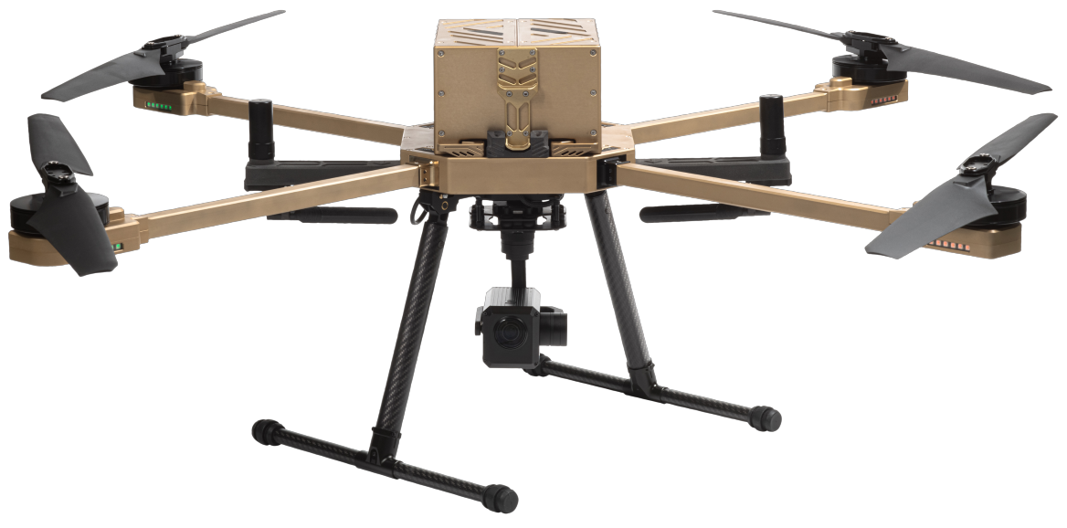
Nextech recommends the Atlas-T solution with thermal and optical zoom sensors for Surveillance and Security Applications. This solution is particularly effective for flying over populated areas as drones can recover and return to home in case of major system failure. The Nextech Security solution is the ultimate security and surveillance drone and you will never require any other.
At Nextech we focus on the design, manufacture, and marketing of long-range UAVs for industrial strength commercial use. With endurance times of up to one 1 hour, and payloads of up to 8kgs, Nextech Drones’ long-range UAVs have huge benefits for business and commerce. Solutions can also be developed to meet specific client requirements, and services can include support and training during and after implementation.
Nextech has a strong team of engineers dedicated to their customers. We additionally service an international base of clients ranging from South Africa to the UAE. Clients include representatives from the following industries: Infrastructure, Security, Real Estate, Security, Agriculture, Game Farms, Wildlife Management, Electrical Installations, Telecommunications, Wind farms.